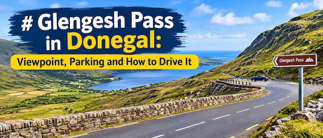
Most people who drive the R230 in south-west Donegal don’t see it coming. You’re crossing quiet bog and sheep country, the road tips over a rise, and the whole glen opens up below you with a ribbon of tarmac folded down the side of it like a dropped shoelace. That is Glengesh Pass, and it is one of the best short drives anywhere on the Wild Atlantic Way.
This guide covers what you actually need on the day: where the viewpoint is, where to park, which direction is better, how to handle the bends, what is close by, and the questions people ask most. If you are building a longer trip around Donegal, read it alongside our other Irish travel stories on Dreaming Ireland.
Glengesh Pass at a glance
| Detail | Information |
| Name | Glengesh Pass (Irish: Malaidh Ghleann Gheis), meaning Glen of the Swans |
| County | Donegal, Ulster, Republic of Ireland |
| Road | R230, about 23 km long between Glencolmcille and Common Bridge near Ardara |
| Highest point | Roughly 270 metres above sea level |
| Address for sat nav | Glengesh Viewing Point, R230, Glengesh, Ardara, Co. Donegal |
| Coordinates | About 54.7206 N, 8.4846 W |
| Drive time to Ardara | About 10 minutes |
| Drive time to Glencolmcille | About 25 minutes |
| Entry fee | None. It is a public road |
| Best for | Scenic driving, photography, cycling, a short stop on a Slieve League day |
| Time needed | 20 to 30 minutes for the pass alone, half a day with nearby stops |
What is Glengesh Pass, exactly?
It is a stretch of regional road, nothing more mysterious than that. The R230 links the Gaeltacht village of Glencolmcille with the town of Ardara, and somewhere in the middle it has to get over a mountain shoulder. The engineers’ answer was a series of tight hairpin bends that drop into the valley floor. A Wikipedia entry on the R230) lists the road at just over 23 kilometres in total, and the pass is the only part of it anyone remembers.
The valley itself was carved by ice. Glengesh is one of two glaciated valleys along the northern edge of the Banagh peninsula, which is why the sides are so steep and the floor so flat and green. The Irish name translates as Glen of the Swans, though you are far more likely to meet a ewe on the road than a swan.
The Lonely Planet entry for the pass describes the approach as a run of switchbacks past remote bogland, and that is fair. It is wild country, not manicured scenery, which is exactly why it works.
Where to find it and how to get there
Glengesh sits in the south-west corner of County Donegal, roughly midway between two of the area’s best-known stops. From Ardara you leave town on the N56 and turn onto the R230 at Common Bridge. From Glencolmcille you climb inland out of the village and the road does the rest.
Public transport will not get you to the viewpoint in any practical way. A hire car is the normal answer, and if you are flying into the north-west, Donegal Airport and City of Derry Airport are the closest options. Plenty of visitors pair the pass with a day around Killybegs and the cliffs, since the roads join up neatly.
Which direction is better?
Come from the Glencolmcille side if you can. You reach the viewpoint first, you get the full reveal of the valley from above, and then you drive down into it with the view in front of you rather than behind. Coming up from Ardara works fine, but you climb through the hairpins before you ever see the shape of the glen, which is a bit like reading the last page of a book first.
The viewpoint and parking
The main stop is a small lay-by at the top of the pass on the Glencolmcille side, signed on maps as Glengesh Viewing Point. It holds only a handful of cars once everyone parks sensibly, so don’t expect a coach park or a visitor centre. There is a low wall to sit on and, in the busier months, a coffee cart sometimes turns up. Don’t count on it, though. Bring a flask if you care about your tea.
A second, even smaller pull-in sits just before the first bend as you start to descend. It is fine for a quick photograph, but be careful stopping on a blind curve. If the lay-by is full, wait a minute and someone will move; people rarely stay long.
Parking here is free. The viewpoint has no toilets, no bins worth mentioning, and no shelter, so take your rubbish with you and use the facilities in Ardara or Glencolmcille before you set off.
How to drive Glengesh Pass without a sweat
The road is not dangerous if you treat it properly, but it is not forgiving either. The bends are tight, the surface can be damp or greasy, and fog sits in the glen more often than you would like. Local news sites such as Donegal Live have reported lorries getting stuck on the pass, which tells you something about what happens when a large vehicle meets a hairpin.
- Keep your speed right down on the descent. Use a lower gear instead of riding the brake the whole way.
- Don’t cut the inside of a bend. Oncoming cars and cyclists will be right there.
- Large campervans and coaches should think twice. The road is passable, but passing places are not generous.
- Check conditions before you leave. Resurfacing works and the odd breakdown have closed the R230 before, and the diversion runs the long way via Killybegs.
- In fog or heavy rain, there is no shame in waiting at the top for twenty minutes. The glen will still be there.
If you are nervous on mountain roads, take the descent from the Glencolmcille side. Gravity is on your side for the first stretch, and you can pull in at the viewpoint to settle yourself before the real bends begin.
On foot or on a bike
Cyclists love the pass because the climb is steady rather than brutal and the descent is the kind that makes you grin. Wilderness Ireland has included Glengesh in its roundup of the best climbs and descents in Ireland, and a loop from Killybegs through Glencolmcille and over the pass makes a proper day out. Just remember that cars are close and the bends are blind. Lights and bright clothing are sensible even in summer.
Walkers can stroll a short section from the viewpoint for a feel of the valley without committing to anything long. There is no marked trail in the usual sense, so wear proper footwear, stick to the verge, and keep to the side facing traffic.
The best time to visit
Early morning and early evening are the sweet spots. The light is lower, the lay-by is emptier, and the glen has more shape. Midsummer is the busiest period, though even then you will rarely be queuing for a space. Winter drives are still possible, but frost on the bends and shorter days make it a less relaxed outing.
Weather decides everything here. A clear day gives you long views down the valley and out towards the coast. A misty day makes it moody and atmospheric, but you will not see much. Check a local forecast on the morning you go, and keep half an eye on the sky as you drive.
What to see near Glengesh Pass
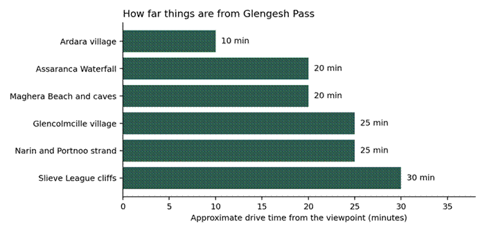
The pass is short, which is a gift. You can fit it into a bigger day without losing an afternoon to it. Everything below is within a half hour by car, and together they make a very good loop.
| Place | Drive time | Why go |
| Ardara village | 10 min | Tweed shops, good pubs and a proper lunch stop |
| Assaranca Waterfall | 20 min | Roadside waterfall that needs no hiking |
| Maghera Beach and caves | 20 min | Wild, empty beach with sea caves reachable at low tide |
| Glencolmcille village | 25 min | Folk village, ancient crosses and a strong Irish language culture |
| Narin and Portnoo strand | 25 min | Long sandy beach, quiet outside high summer |
| Slieve League cliffs | 30 min | Some of the highest sea cliffs in Europe |
Take care at Maghera. Tides and currents are strong, and the caves can cut off quickly, so check times locally before heading in. At Slieve League, stay behind the barriers and don’t gamble with the wind at the edge.
If you like the idea of chasing odd and unexpected roadside sights across the country, our story on the Connemara Giant in Recess, Co. Galway is a fun example of the kind of stop that rewards a slow drive.
A simple half-day plan
- Start in Ardara with breakfast or coffee and a quick look at the tweed shops.
- Drive the R230 up and over the pass and stop at the viewpoint on the way down towards Glencolmcille.
- Spend an hour in Glencolmcille for the folk village or a short coastal walk.
- Continue to Slieve League for the cliffs, then loop back through Killybegs on the R263.
- Finish with seafood in Killybegs or a pint back in Ardara.
Reverse it if you are based in Glencolmcille. Either way, leave room in the day for stopping. The point of this road is not to get anywhere fast.
The pass also fits neatly into a wider coastal itinerary. The Wild Atlantic Way runs right past it, and many people add it to a longer drive that links Donegal with Sligo, Mayo and beyond.
Our rating of Glengesh Pass
| Category | Score | Comment |
| Scenery | 4.5 / 5 | Dramatic glen, especially from above |
| Driving experience | 4.5 / 5 | Hairpins are fun when taken slowly |
| Facilities | 1.5 / 5 | Lay-by and a wall, little else |
| Crowds | 4.5 / 5 | Usually quiet, even in season |
| Value | 5 / 5 | Free, and easy to fit in |
| Overall | 4.4 / 5 | Worth the detour every time |
This is our own editorial score based on what the place offers, not a collection of visitor reviews. Facilities are limited, so plan accordingly.
Final thoughts
Glengesh Pass doesn’t need a long walk, a ticket or a plan. It needs a clear-ish day, a steady foot and a few minutes at the top to take it in. Combine it with Slieve League, Maghera and Ardara and you have one of the finest short loops in Donegal, with very little traffic to spoil it.
Frequently asked questions
Is Glengesh Pass worth visiting?
Yes. It is free, it takes under half an hour, and it gives you one of the most photogenic stretches of road in Donegal. It is especially worth it if you are already heading between Ardara and Glencolmcille, since you have to cross it anyway. Guides such as the Rough Guide to Donegal also single it out as the dramatic route through the heart of the peninsula.
Where is Glengesh Pass?
It is on the R230 in south-west County Donegal, between Ardara and Glencolmcille. The R230 road page on Wikipedia) gives the route details and length.
Where do I park at Glengesh Pass?
Use the small lay-by at the top on the Glencolmcille side, signed as Glengesh Viewing Point. A second, smaller pull-in sits just before the first bend. Space is limited, so be patient and don’t block the road.
How high is Glengesh Pass?
It reaches about 270 metres above sea level, according to the Frommer’s guide to the Donegal Bay coast, before dropping through hairpin bends into the valley.
How long does it take to drive?
The pass itself takes only a few minutes, but allow 20 to 30 minutes with a stop at the viewpoint. The full run from Ardara to Glencolmcille is roughly 35 to 40 minutes at a relaxed pace.
Is the road safe for nervous drivers?
It is manageable if you go slowly. Take the descent from the Glencolmcille side, use a low gear, and avoid driving it in thick fog. If you have a large vehicle, consider the longer route via Killybegs instead.
Can you cycle Glengesh Pass?
Yes, and it is popular with road cyclists. Wilderness Ireland lists it among Ireland’s best climbs and descents. Wear high-visibility gear because the bends limit sightlines.
Is there a toilet or cafe at the viewpoint?
No toilets. A coffee cart sometimes operates in busy months, but it is not guaranteed. Use the facilities in Ardara or Glencolmcille.
What is the Irish name of Glengesh Pass?
Malaidh Ghleann Gheis, often shortened to Gleann Gheis. The English name means Glen of the Swans.
What else can I see nearby?
Assaranca Waterfall, Maghera Beach, Narin and Portnoo strand, Glencolmcille Folk Village and Slieve League are all within about half an hour. For more Irish travel ideas, browse the Dreaming Ireland blog.
Related posts
- The Connemara Giant: Modern Irish Mythology in Recess, Co. Galway
- More Ireland travel stories on the Dreaming Ireland blog
Disclaimer
Road conditions, parking arrangements, opening hours, drive times and weather in Donegal can change without notice. The information in this article is provided for general guidance only. Please check local conditions, follow road signs and use your own judgement before travelling. Drive times are approximate and depend on traffic and weather. Dreaming Ireland accepts no liability for loss, injury or inconvenience arising from use of this guide.